McArthur River Manganese Project (Genesis 100%)McArthur River Management PlanThe McArthur River project is located approximately 850 kilometres south east of Darwin in the Northern Territory. The project comprises one granted Exploration Licence (EL 24814) which covers a total area of 380.88 sq km that is easily accessible from the Carpentaria Highway and is only 265 kilometres by road from the port at McArthur River mine.
The McArthur River project hosts three known areas of outcropping manganese
mineralisation. The most significant known manganese outcrop on the McArthur
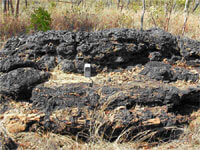
River project is the Masterton No.2 prospect. The Masterton No.2 prospect
contains a vertical and steeply dipping manganiferous lense that is up to 160
metres long and averages 10 metres in width that has assayed up to 63% Mn.
A brief reconnaissance rock chip sampling program was conducted over the
Masterton No.2 prospect and the surrounding areas in October 2008. Out of the
fourteen rock chips, twelve rock chip assays returned ore grade values of
manganese varying from 43.5% to 53.1% Mn from surface. 
| | 
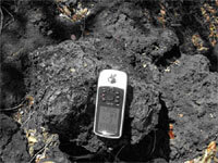
| Massive outcropping manganese mineralisation over Masterton No.2 Prospect | | Masterton No2 example of massive Mn outcrop |
| |
|
| 
